 As a journalist, I’ve written about crime for newspapers, business deals for magazines, cruise ship ports for online travel publications and industry trends for websites. My focus now is exclusively on travel.
The glowing orange sphere slowly peaked above the dark walls of the “Grand Canyon of Texas,” illuminating subterranean spires, buttes, and mesas bathed in soft terra cotta colors. Watching the stunning sunrise over Palo Duro Canyon was well worth skipping soggy scrambled eggs and dry bacon from the hotel breakfast buffet. But I was sorry I waited so long.
Palo Duro Canyon State Park has been on my travel list almost since I moved to Texas two decades ago. But every time I was near the second-largest canyon in the U.S., the weather discouraged me. It was too cold, when I drove through the Texas Panhandle en route to ski trips in New Mexico. It was too hot in August as I headed to Colorado to escape 100-degree temperatures in Austin.
September 2020 was different—and not just because of the coronavirus. I postponed our get-out-of-Texas trip several times because of wildfires in western Colorado. By mid month, temperatures dropped into the 90s. I was ready to bolt.
Caprock: where bison still roam
No more excuses. I reserved day passes for Palo Duro Canyon State Park and for nearby Caprock Canyons State Park, where the state’s bison herd roams.

The canyons of the Panhandle are often overlooked, even by Texans. The vast western half of the state is mostly empty, flat, and practically tree-less. It’s generally considered a place to drive through at high speeds, with minimal stops. In addition, neither canyon is easy to reach: Palo Duro is about 30 miles east of Amarillo, while Caprock is about 100 miles southeast of Amarillo.
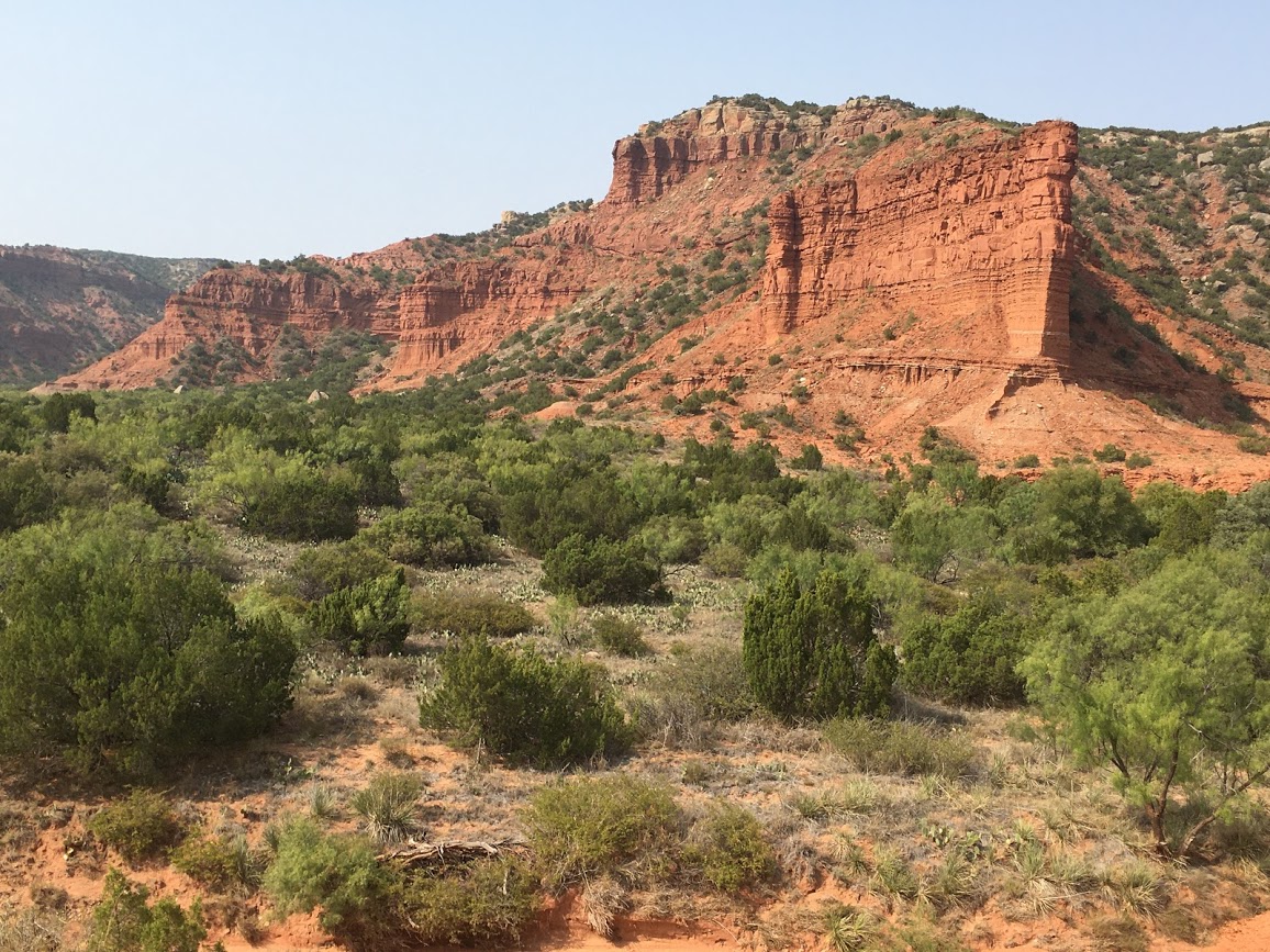
But these gaping cracks in an otherwise unremarkable landscape share a common geology. They sit between the flat, high plains of the Llano Estacado that continue west into New Mexico and the lower, rolling Great Plains to the east that extend all the way north to Canada. Over millions of years, water flowing east into the Red River has eroded layers of rock into different shapes and colors ranging from deep reds to burnt oranges and even bands of white.
Palo Duro resembles Grand Canyon
Palo Duro is better known and larger—about 120 miles long and 5-20 miles wide, with depths reaching nearly 1,000 feet. Palo Duro is an enclosed basin similar to the Grand Canyon, while Caprock is a series of rugged cuts slashed into more than 15,000 acres.
Since Caprock is closer—400 miles northeast of Austin—we headed there first. Traveling on mostly two-lane roads, the drive took nearly seven hours. As the Texas Hill Country faded into mostly flat dusty plains, we counted nearly as many “forests” of towering wind turbines as herds of cattle as we rolled through miles of Texas ranchland. In many of the small towns we passed through, store fronts were boarded up while the parking lots in front of “Dollar” discount stores buzzed with activity.
Lulled by the conformity of West Texas, the sudden collapse of the land ahead into the incongruous yet striking canyons of Caprock was startling. Then we saw about two dozen shaggy bison grazing in the foreground. Traffic stopped as the buffalos ambled along the road near the visitors’ center and down to Lake Theo.
Bison cool off in Lake Theo
After snapping a few pictures, we spread our picnic on a table overlooking Lake Theo, mesmerized as the herd, including several playful youngsters, waded into the water to drink and cool off.
The bison’s ancestors were hunted to near extinction in the late 1870s. Fortunately, the wife of legendary rancher Charles Goodnight, whose vast holdings once included much of the Panhandle, rescued several calves left to die. After the state bought land for Caprock in 1975, the bison were relocated to the park.
Unfazed by people, the bison roam freely through much of the park. But rangers warn visitors not to get within 50 feet of the fury critters. Bison can run up to 35 miles per hour. When agitated, their tails rise in the shape of a question mark.
Hiking trails meander through Caprock
From the lake a scenic drive winds around red-rock ridges and along narrow creek beds to the canyon floor. You can pull off the road to admire unusually shaped peaks and pinnacles. About 25 miles of hiking trails meander through Caprock, which also has a mix of primitive and improved campsites. You can also explore the canyons on horseback or on mountain bikes.
We hiked briefly on several of the park’s trails amid vegetation that varies from prickly pear cacti, juniper, and scrub oaks in the western part of park to mostly grasses along river beds, which were dry when we visited.

Too warm for a long hike, we str olled around Honey Dog Prairie Town instead to observe the quirky behavior of the park’s black-tail prairie dogs.
Canyon hotels convenient to Palo Duro
We spent the night in Canyon, the closest town to Palo Duro with a range of hotel and restaurant options. We picked up dinner from Feldman’s Wrong Way Diner, an iconic café known for its chicken fried steak and Old West movie posters.
When we left our hotel the next morning it was so dark we didn’t glimpse Palo Duro Canyon until we pulled into the lookout near the visitors’ center. Alone except for a man with a camera on a tripod aimed at the eastern walls of the canyon, we didn’t need a long lens to be awed by the stunning sunrise as it awakened the vast canyon.
Palo Duro’s history runs deep. The canyon sheltered several Native American tribes before Spanish explorers passed through in the 1500s and named it Palo Duro (Spanish for “hard wood”). The fierce Comanche, led by Quanah Parker, staged what was to be their last stand there against U.S. troops during the Red River Wars in the 1870s. After they were banished to an Oklahoma reservation, Charles Goodnight moved cattle into Palo Duro in 1876.
Cattle ranch becomes state park
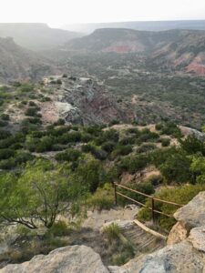
Land for the park, which was once part of a vast ranch of 1.3 million acres with 100,000 head of cattle, was bought by the state in 1933. Soon after, in the midst of the Great Depression, workers from the Civilian Conservation Corps spent the next five years creating the park. Workers hiked single-file on what is now the CCC Trail until they built the twisting16-mile road to the canyon floor.
That trail was too steep for me so we drove into the canyon, enjoying sweeping views in all directions as the sun lit up the craggy rocks. The parking lot was already crowded at the park’s most popular trail to the Lighthouse. We hiked far enough to see the Lighthouse rock, an eroded sentinel or hoodoo that symbolizes the park. Then we detoured onto the Rojo Grande trail, which follows a dry riverbed along burnt orange canyon walls. The park has 30 miles of trails for hiking, biking, or horseback riding as well as campsites and cabins for overnight stays.
As we left the canyon I noticed the empty amphitheater. In pre-pandemic summer months, actors in period costumes retell the settling of the Lone Star state in a rollicking musical drama entitled “Texas.”
Seeing the sunrise over Palo Duro Canyon was enough drama for me on this visit. But I’m already planning a return trip to watch the sunset and—if I time it right—wildflowers blooming in the canyon next spring.
